Schedule a free consultation Let’s Go
Success Story
Rockfall Hazard Analysis
The Mission
Monitor the movements of rock on the steep slopes next to Colorado mountain highways."UAS provides a technologically advanced, cost efficient way of capturing remotely sensed data of an entire corridor over time." Colorado Department of Transportation
Mission Objectives
Falling rock causes serious damage to roadways and can injure or kill motorists. State departments of transportation are responsible for mitigating these risks by removing or stabilizing rocks and slopes. The client wanted to design a program to generate highly accurate 3-dimensional models to monitor the movement of rock over time. These models will be combined with predictive analytics technology to determine the likelihood of specific rockfall events in the future. The data would need to be acquired in highly challenging terrains where GPS may not be available. Additionally, the operations would need to be safely performed near highways with minimal obstruction of traffic.
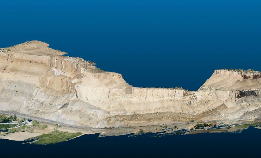
A digital model of a cliffside in Debeque Canyon, Colorado. The model combines LiDAR and aerial imagery to generate a highly accurate three-dimensional surface.
The Solution
Juniper Unmanned innovated a highly advanced solution for the client that involved capturing LiDAR and Imagery data with drones. We modified a LiDAR unit and integrated it on a drone to enable side scanning. We developed a flight planning solution that allowed the aircraft to fly at a consistent distance from the ground (terrain following). The team collaborated with the state to establish safety protocols. Likewise, we established the procedures to collect the data to the local grid coordinate systems. Juniper was asked to support the program by providing ongoing data processing and data hosting services. We also provide ongoing consultation for the DOT UAS programs to ensure they are well trained and prepared to address the challenges in the future.