Schedule a free consultation Let’s Go
Success Story
Mineral Exploration
The Mission
Design a process for rapidly conducting high-resolution magnetic surveys to assist in locating gold and copper ore deposits.
"Juniper Unmanned has been at the forefront of Unmanned Systems and Magnetometry for years, and they have a huge variety of surveys under their belt." - Geometrics, maker of the MagArrow magnetic sensor.
Mission Objectives
A mining exploration company approached Juniper Unmanned to determine if there were remote sensing technologies that could detect buried ore bodies, specifically copper porphyry deposits. Their objective was to reduce the level of effort required to find and quantify the deposit. The company’s areas of exploration are high in the Rocky Mountains in very rugged environments where walking surveys are not realistically feasible. They also were very sensitive to the confidentiality of the location and had a high need for data security.
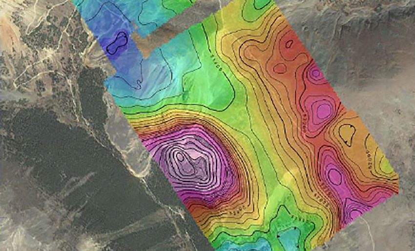
A magnetic intensity map identifying the specific underground location of the mineral deposit
The Solution
Juniper Unmanned conducted research on magnetic sensors that could be operated from a drone and ultimately determined that the Geometrics MagArrow product was the right tool for the job. We experimented with hardware integrations and settled on a system of slings that keep the sensor a safe distance from the magnetic signature of the drone as it is flying. Next, we developed the data processing and geophysical interpretation system to support client’s ongoing needs. A standard operating procedure for operating a slung load was established and the flight planning tools were modified to accommodate the procedures. Juniper was asked to develop a training curriculum for the client and to train operators around the world. Additionally, we maintain a core competency in magnetic data acquisition and interpretation.