Schedule a free consultation Let’s Go
Success Story
Bridge Scour
The Mission
Develop a technology to model streambeds around bridges and monitor the movement of sediments.Mission Objectives
Fast moving water can carry off sediment around bridge substructure, exposing the footings or piles. When the streambed is washed away, bridge support can be compromised, putting the bridge at risk. Scour is a leading cause of bridge failure. Departments of transportation need to monitor these structures closely, especially during high-water. This is a difficult and dangerous task. Typically, inspectors launch a boat and probe the channel bottom with metal rods, weighted tape measures or sonar devices. Juniper Unmanned was asked if we could develop methods for conducting these inspections using unmanned aircraft systems. The system would need to operate above water and be able to visualize the substructure at varying depths with potentially turbid flows.
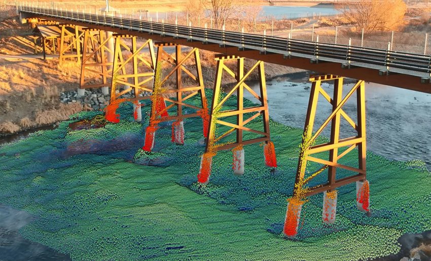
A 3-dimensional model of a bridge substructure using the Astralite Edge LiDAR system.
The Solution
Juniper Unmanned solutions engineers collaborated with the team at Astralite to design and develop a bathymetric LiDAR unit that could be carried reliably on a multirotor UAV. The sensor would need to provide surface scanning rather than line scanning like most bathymetric LiDAR systems. It would also need to have the ability to model the water surface and the shorelines. Once the hardware was developed by Astralite, Juniper integrated the unit and tested it with governmental partners and clients. We developed the tactics, techniques, and procedures to operate the system reliably. This project resulted in a remarkable new technology for departments of transportation around the country. Juniper Unmanned, then trained our internal personnel to ensure our DOT clients can easily benefit from the world’s first small-scale airborne bathymetric and topographic multi-sensor LiDAR system, the ASTRALiTe EDGE.